[Press Release] First Confirmation of Japanese Deer Wintering at Altitudes Exceeding 1,600 Meters in Kamikochi Using GPS Tracking Technology
On May 25, 2026, our company issued a press release titled “[First Confirmation] GPS Tracking Technology Demonstrates Deer Overwintering at Altitudes Exceeding 1,600 m in Kamikochi” via PR TIMES. Using our GPS collars“LoggLaw G2C” and our wildlife data management cloud platform “Animal Portal,” we have demonstrated for the first time in Japan that Japanese deer remain in forested areas at elevations exceeding 1,500–1,600 meters in Kamikochi, Northern Alps, throughout the winter.
Full press release: https://prtimes.jp/main/html/rd/p/000000007.000114250.html
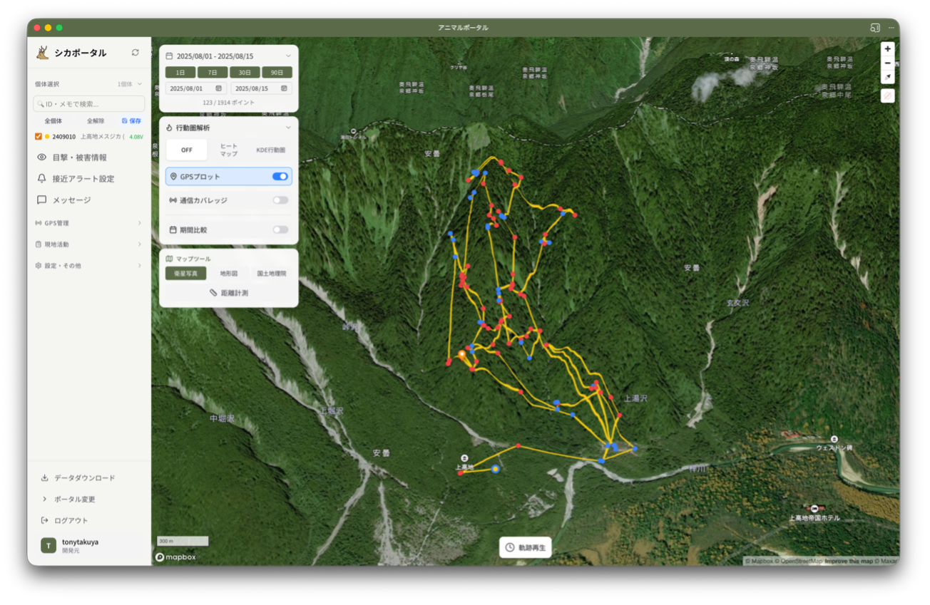
Survey Overview
This study was conducted by our company in collaboration with the Kamikochi Branch of the Nature Parks Foundation (contact: Mr. Sohei Katori) and Professor Shigeyuki Izumiyama, a Specially Appointed Professor at Shinshu University.By continuously tracking the location of a Japanese deer equipped with a LoggLaw G2C via Animal Portal, we confirmed that—contrary to the previously held assumption that “deer move to high-altitude areas only in summer and descend to lower elevations in winter”—the tracked individual remained in the Kamikochi forest zone at elevations exceeding 1,600 m throughout the winter.
Furthermore, since the tracked individual was a pregnant female, this suggests the possibility that breeding is occurring in the Kamikochi area, highlighting the growing need for an assessment of the impact on the alpine ecosystem and for scientific wildlife management.
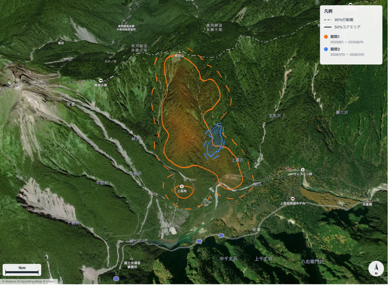
Products and Services Used
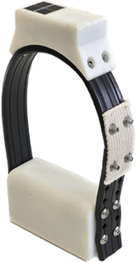
- LoggLaw G2C (Collared GPS for Wildlife Damage Control) — A next-generation GPS collar equipped with LTE-M communication and a solar panel. It supports long-term monitoring in mountainous and cold regions.
- Animal Portal (Wildlife Data Management Cloud) — A cloud platform that visualizes GPS positioning data in real time on a map and enables sharing and analysis across multiple organizations.
Significance and Future Developments
This is the first study in Japan to demonstrate the overwintering of Japanese deer in the forest zone of Kamikochi at an elevation exceeding 1,600 meters; it provides crucial foundational data for the conservation of Kamikochi’s ecosystem, including its alpine plant communities.Moving forward, we will continue to collaborate with research institutions, local governments, and national park administrators to support science-based wildlife management using GPS collars and cloud infrastructure.
Inquiries Regarding This Matter
Biologging Solutions Co
., Ltd. TEL: 075-746-7858
E-mail:contact@biologging-solutions.com
Related Products and Services
LoggLaw G2C — Collar-Type GPS for Wildlife Damage Control (GPS Collar)
A collar-type GPS designed for medium- to large-sized animals. It combines GNSS positioning, LTE-M communication, and a solar panel to enable long-term, real-time tracking in mountainous environments.Its adoption is growing for behavioral studies of deer, monkeys, and bears, as well as for wildlife damage control. For details specific to each target animal, please visit the respective pages: GPS Collars for Monkeys, GPS Collars for Deer, and GPS Collars for Bears.
Animal Portal — Cloud-Based Wildlife Data Management
This cloud platform enables real-time visualization and sharing of GPS data collected by the LoggLaw G Series. It supports the display of activity ranges on maps, proximity alerts, and data sharing among multiple organizations (area notifications via geofencing are currently in beta).