LoggLaw DiveSat
A data logger for diving marine animals that sends its dive record to the Argos satellites in the moment the animal surfaces. Data reaches you whether or not the tag is recovered, and if you do recover it, the full-resolution 4-second record is still on board. DiveSat-GPS adds GPS fixes for studies that need positions.
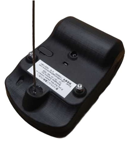
LoggLaw DiveSat belongs to the category of devices known in biologging research as satellite tags, Argos tags, or satellite-linked data loggers. The tag keeps the full dive record on board and sends the essentials to the Argos satellites at every surfacing, which suits open-ocean and long-range studies where recovery cannot be assumed.
Key Features
Transmits to Argos at every surfacing
While the wet/dry sensor reads air, the tag repeats its stored data roughly every 60 seconds. Each transmission carries 20 bytes of user data.
Data arrives without recovery
Transmitted messages are collected through Kinéis / CLS, then decoded and stored on our side. Even when the animal is never recaptured, dive summaries and positions are in your hands.
On-board record every 4 seconds
Depth, water temperature, wet/dry state and battery voltage are logged every 4 seconds. If the tag is recovered, connect over USB and read out the full-resolution record of roughly the most recent 8.3 days.
One dive, one message
When a dive ends, the tag extracts the break points of the depth trace with a Broken Stick Model and sends them as time-and-depth pairs. Up to 6 points are sent (4 by default).
GPS positions on DiveSat-GPS
Both models yield Argos Doppler locations. DiveSat-GPS also takes a GPS fix from a 30 ms capture at every detected surfacing, with 25 m accuracy in the uplink.
Delivered through BiP
Data received over the satellite link is decoded on our side and delivered through BiP (Biologging intelligent Platform), our research data platform.
What the tag does over one deployment
attach → record → transmit at every surfacing → (if recovered) full data
A diving animal is at the surface only for the length of a breath. DiveSat detects that surfacing with a wet/dry sensor and sends the dives it has recorded to the Argos satellites. One transmission carries 20 bytes, so the full 4-second record stays on board and only the essentials go into the uplink.
- 1
Attach and release
Fix to the carapace, remove the wet/dry short cable, release
- 2
Measure every 4 s
Depth, water temperature, wet/dry and battery voltage on board
- 3
Summarise each dive
At the end of a dive, extract the break points of the depth trace
- 4
Transmit at the surface
While air is detected, transmit to Argos roughly every 60 s
- 5
Receive and decode
Collected through Kinéis / CLS, decoded and stored on our side
If the tag is recovered
Connect over USB and read out the full-resolution 4-second record (most recent 8.3 days)
Argos is a one-way link. There is no acknowledgement and no retransmission request, so the tag repeats stored messages, newest first, for as long as it is at the surface.
Typical studies
- Diving behaviour of air-breathing animals such as sea turtles and pinnipeds
- Long-range movement where recovery cannot be assumed
- Diurnal and seasonal change in dive depth and duration
- Time spent hauled out on land
- Vertical temperature structure the animal experienced
- Post-release survival and range
Suited to
- Getting data reliably from animals you may never recover
- Following dive depth and duration over long periods
- Knowing where the animal is to within a few hundred metres (DiveSat-GPS)
Consider another option if you need
- Sub-second behaviour or body orientationLoggLaw C series (recovery required)
- Underwater video or soundLoggLaw CAM
- Positions of terrestrial animalsLoggLaw G2C / G2S
What the tag transmits
One transmission carries 20 bytes of user data. What goes into that budget decides what you are left with when a tag is not recovered. DiveSat builds five kinds of message (DiveSat-GPS adds Position, the GPS fix, for six), and the order in which they are sent is configurable.
Message types
| Type | Contents | Sent per |
|---|---|---|
| Dive Profile | Depth trace of one dive, as pairs of time (% of dive duration) and depth | dive |
| Summary | Dive count, maximum and mean depth, maximum and mean dive duration, proportion of time diving, maximum / minimum / mean water temperature, battery voltage | summary period |
| Hauled out | Record of time spent on land | haul-out |
| Temperature Cast | Vertical profile of water temperature | cast |
| Position | GPS fix (DiveSat-GPS only) | fix |
| Temporary | Status notification such as voltages | when none of the above is queued |
Transmission
| Trigger | While the wet/dry sensor reads air, the tag transmits whatever is queued, repeatedly. There is no fixed number of messages per day. |
|---|---|
| Interval | About 60 s, with ±10 % jitter (54 to 66 s) |
| Message size | 20 bytes of user data (31-byte payload including error-correction coding) |
| Order | A priority is set per message type. There is no scheduling by time of day or by latitude. |
| Missed messages | No individual retransmission request. Messages are held in on-board Flash and repeated, newest first. |
How much gets through depends on how long the animal stays at the surface.
Only transmissions that complete during a surfacing are sent. For species that surface briefly at each breath, a single dive may not get its message away. Summary period and priorities are tuned to the surfacing pattern of the study species.
How a dive profile is sent
Depth is recorded every 4 seconds. When a dive ends, the tag extracts the break points of that depth trace with a Broken Stick Model and sends them as time-and-depth pairs. One dive becomes one message. The number of points sent is configurable (up to 6; the factory default is 4).
Depth resolution in the uplink
| 0 to 2.55 m | 0.01 m |
|---|---|
| to 25.5 m | 0.1 m |
| to 255 m | 1 m |
| to 2,550 m | 10 m |
Resolution is finer near the surface and coarser with depth. This is the range the uplink format can express; the pressure rating and measurement range of the tag are separate figures.
Dive detection
| Start threshold | About 2.9 m (implemented as 1.31 bar absolute; with the 4-second interval, detection takes 12 s in practice) |
|---|---|
| Duration | Held beyond the threshold for more than 8 s |
| Uplink unit | 1 dive = 1 message |
| On board | The detailed trace behind the profile is also kept |
Positioning
Positions come from two sources. Argos Doppler locations are computed from the transmissions themselves and are available on both models. GPS, on DiveSat-GPS, takes a fix at every surfacing for studies that need higher accuracy.
Argos Doppler
both models| Source | Computed by Argos each time a transmission is received |
|---|---|
| Accuracy classes | Location Class 3 to B, each with an error radius |
| Cost to the tag | None beyond the transmission itself |
| Field trial | 59.9 % in Class 3 to 1; mean error radius 937 m *1 |
GPS
DiveSat-GPS only| Acquisition | A 30 ms capture at every detected surfacing (every 150 s when on land) |
|---|---|
| Accuracy | 25 m in the uplink, with 5 satellites *2 |
| Processing | Cloud processing required; an assistance (BAS) file is written in advance |
| Field trial | 84.9 % of attempts fixed (404 / 476) *1 |
Operating requirements
| Initial fix | The tag takes an initial fix outdoors when measurement starts, normally within 2 to 3 minutes (red LED blinking, then green LED blinking). |
|---|---|
| BAS file | Written before shipment. If the tag is deployed more than a month after delivery, the file needs updating. |
| PTT ID and contract | The Argos PTT ID, the radio licence and the Argos system fees are arranged and paid by the user. |
| Radio regulation | Operated in Japan under an experimental station licence. Outside Japan, national regulations apply. |
*1: From the Kumejima trial of April to May 2026 (one sea turtle, one DiveSat-GPS, 17 days). Results depend on the animal, the sea area and how often it surfaces, and are not guaranteed performance.
*2: The uplink carries five satellites, which caps accuracy at 25 m. The on-board record has no such limit: 22 m with 6 satellites, 20 m with 7, 18 m with 8.
Attachment
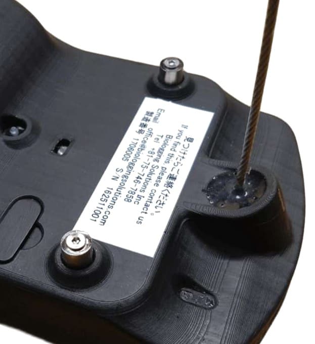
The housing is 115 × 75 × 42 mm and weighs about 315 g in air. The attachment face is curved to follow a carapace, and the sensors and antenna sit on the upper face. Because transmission happens in the moment of a surfacing, mount the tag so that the upper face is clear.
Size and weight
| Item | DiveSat | DiveSat-GPS |
|---|---|---|
| Housing | 115 × 75 × 42 mm | 115 × 75 × 42 mm |
| Antenna | 165 mm above the housing (183 mm overall) | 165 mm above the housing (183 mm overall) |
| Weight in air | 315 ± 10 g | 320 ± 10 g |
| Weight in water | approx. 200 g | approx. 205 g |
Points to observe when mounting
- Sensors and the GPS / Argos antenna are on the upper face. Do not cover them with resin or putty.
- Remove the wet/dry short cable immediately before release; the tag will not transmit while it is fitted.
- If more than an hour passes between setup and release, fit the short cable to save the battery.
- Fit the connector cap and the sealing tape before attaching the tag.
Field trial results
In April and May 2026 a DiveSat-GPS was deployed on one sea turtle at Kumejima, Japan, and received for 17 days. The figures below are what was measured. They come from one animal and one tag, and are not guaranteed performance.
Breakdown of what was received
| Doppler location classes | Class 3: 24.1 % / Class 2: 28.2 % / Class 1: 7.6 % / Class 0: 4.4 % / Class A and B: 35.7 % |
|---|---|
| Error radius | Mean 937 m (min. 150 m, max. 17,933 m) |
| Against the GPS fix | Mean separation from the Doppler location 343 m, median 300 m (399 records) |
| Data integrity | CRC pass rate 91.6 %. Outliers were almost all removed by the CRC check |
| Satellites | 25 distinct satellites (Kinéis constellation, O3, CS, MC and others) |
Throughput depends on the surfacing pattern of the animal and on satellite passes.
Daily totals ranged from 61 to 226 messages in this trial. Reception at low latitudes has also been confirmed in trials at Ishigaki and Irabu, but conditions vary with the sea area and the study species, so please talk to us beforehand.
Setup and getting the data
Setup is done from a Windows application. Data arrives by two routes: transmitted messages come in over the satellite link, and if the animal is recovered the 4-second on-board record can be read out.
Over the satellite link (no recovery needed)
- Collected from the Kinéis / CLS telemetry API
- Decoded and stored on our side
- Delivered through BiP (Biologging intelligent Platform), our research data platform
After recovery (read out from the tag)
- Connect to a PC with the dedicated interface cable (USB)
- Raw data from every sensor at the 4-second interval (47 bytes per record)
- The detailed trace behind each profile is also available
Setup and read-out
| Application | LoggLawSurf DiveSat / DiveSat-GPS (Windows 11, 64-bit or later) |
|---|---|
| Connection | Dedicated interface cable. Connect tag, then cable, then PC, in that order |
| Configurable | Measurement schedule, uplink priorities, summary period, dive threshold |
| Output | Proprietary binary (.blb) with CSV generated alongside it |
In the box
- Tag (LoggLaw DiveSat or DiveSat-GPS)
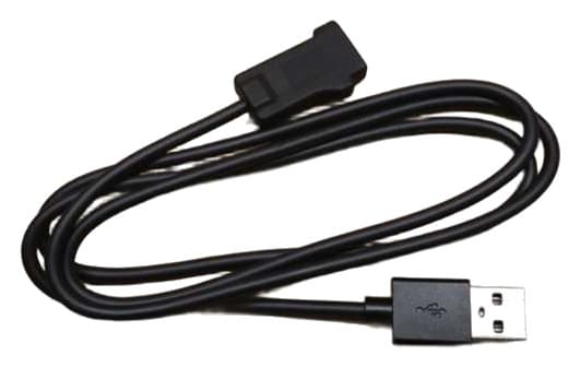
- Dedicated interface cable (for setup and read-out, USB)
- Wet/dry short cable (holds off transmission until release and saves the battery)
- Connector sealing tape (applied over the connector cap before attachment)
- Windows application LoggLawSurf DiveSat / DiveSat-GPS (supplied by your contact)
The measurement area on board is a ring buffer.
About 8 MiB used at the 4-second interval comes round in roughly 8.3 days, after which older records are overwritten. Recovery therefore returns the full-resolution record of the most recent period; for anything earlier, what remains is what was transmitted.
Specifications
Detailed Technical Specifications
Housing
| Dimensions | 115 × 75 × 42 mm (antenna 165 mm above the housing) |
|---|---|
| Weight in air | DiveSat 315 ± 10 g / DiveSat-GPS 320 ± 10 g |
| Weight in water | DiveSat approx. 200 g / DiveSat-GPS approx. 205 g |
| Material | Photocurable resin, sealed by potting |
| Depth rating | 1,000 m |
| Operating temperature | -10 to 40 ℃ |
| Clock accuracy | ±95 s/year |
| Memory | 24 MiB *1 |
Sensors
| Configuration | Depth (pressure) | water temperature | wet/dry | battery voltage |
|---|---|
| Sampling interval | 4 s |
| Depth | Range 1,000 m, accuracy ±1 % FS; resolution 5.5 cm or better on board, 0.01 to 10 m in the uplink (breakdown in the dive profile section) |
| Temperature | -5 to 35 ℃, ±0.2 ℃; resolution 0.005 ℃ or better on board, 0.0024 to 0.039 ℃ in the uplink *2 |
| Calibration | Individually calibrated before shipment (temperature and pressure) |
Satellite link and positioning
| System | Argos-2 (401 MHz, 500 mW output) |
|---|---|
| Transmission | About every 60 s while air is detected; 20 bytes of user data per message |
| Message types | Dive Profile | Summary | Hauled out | Temperature Cast | Temporary (DiveSat-GPS adds Position) |
| GPS | DiveSat-GPS only. 25 m accuracy, one fix per detected surfacing |
| Arranged by the user | Argos PTT ID, radio licence, Argos system contract |
Power and software
| Battery | Lithium thionyl chloride, 19 Ah (non-rechargeable) |
|---|---|
| Application | LoggLawSurf DiveSat / DiveSat-GPS (Windows 11, 64-bit or later) |
| Data format | Proprietary binary (.blb) with CSV |
| Warranty | Six months from first use, up to one year from delivery |
*1: Divided into system and uplink data, measurement data, and detailed data. The measurement area is a ring buffer holding about 8.3 days at the 4-second interval.
*2: Temperature resolution in the uplink varies with the message type: 0.0024 ℃ (water temperature in Summary, 14 bit), 0.01 ℃ (Temporary, 12 bit), 0.020 ℃ (Temperature Cast Method 2, 11 bit), 0.039 ℃ (Method 0, 10 bit).
The battery can be carried by air but is handled as dangerous goods (Section I). The tag is operated in Japan under an experimental station licence; national regulations apply elsewhere.
* Specifications are subject to change without notice for improvement purposes.
See also
LoggLaw C series
Ultra-compact loggers that record depth, temperature, light, acceleration and magnetism at fine intervals, for studies that recover the tag and analyse behaviour and posture at sub-second resolution.
Learn moreLoggLaw CAM
Animal-borne cameras that record underwater video and sound from the animal's point of view, with depth, temperature, acceleration and magnetism on the same time base.
Learn moreBiP
Our research data platform for storing, analysing and publishing biologging data. DiveSat uplink data is delivered through it.
Learn moreWhen you get in touch, tell us the species, the sea area, the attachment surface and the behaviour you want to see. We can advise on uplink priorities and the summary period, attachment, and the Argos paperwork together.
Inquire About LoggLaw DiveSat
For detailed product information, pricing, case studies, and more, feel free to contact us. Our expert staff will propose the best solution for your needs.